The climate within the Earth's surface varies zonally. Most modern classification, which explains the reasons for the formation of one or another type of climate, was developed by B.P. Alisov. It is based on the types of air masses and their movement.
Air masses– these are significant volumes of air with certain properties, the main ones being temperature and moisture content. The properties of air masses are determined by the properties of the surface over which they form. Air masses form the troposphere like the lithospheric plates that make up the earth's crust.
Depending on the area of formation, there are four main types of air masses: equatorial, tropical, temperate (polar) and arctic (Antarctic). In addition to the area of formation, the nature of the surface (land or sea) over which the air accumulates also matters. In accordance with this, the main zonal types of air masses are divided into marine and continental.
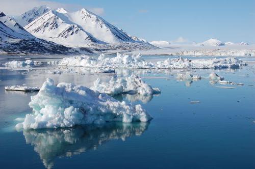
Arctic air masses are formed in high latitudes, over the icy surface of the polar countries. Arctic air is characterized low temperatures and low moisture content.
Moderate air masses clearly divided into marine and continental. Continental temperate air is characterized by low moisture content, high summer and low temperatures. winter temperatures. Maritime temperate air forms over the oceans. He cool in summer, moderately cold in winter and constantly humid.
Continental tropical air formed over tropical deserts. It's hot and dry. Sea air is characterized by lower temperatures and significantly higher humidity.
equatorial air, forming in the zone at the equator both over the sea and over the land, it has high temperature and humidity.
Air masses constantly move after the sun: in June - to the north, in January - to the south. As a result, territories are formed on the surface of the earth where one type of air mass dominates throughout the year and where air masses replace each other according to the seasons of the year.
The main feature of the climate zone is the dominance of certain types of air masses. are divided into basic(one zonal type of air mass dominates throughout the year) and transitional(air masses change each other seasonally). The main climatic zones are designated in accordance with the names of the main zonal types of air masses. U transition zones The prefix “sub” is added to the name of the air masses.
Main climatic zones: equatorial, tropical, temperate, arctic (Antarctic); transitional: subequatorial, subtropical, subarctic.
All climatic zones except the equatorial one are paired, that is, they exist in both the Northern and Southern Hemispheres.
In the equatorial climate zone Equatorial air masses dominate all year round and low pressure prevails. It is humid and hot throughout the year. Seasons of the year are not expressed.
Tropical air masses (hot and dry) dominate throughout the year tropical zones. Due to the downward movement of air that predominates throughout the year, very little precipitation falls. Summer temperatures here are higher than in the equatorial zone. The winds are trade winds.
For temperate zones characterized by the dominance of moderate air masses throughout the year. Western air transport predominates. Temperatures are positive in summer and negative in winter. Due to the predominance low blood pressure There is a lot of precipitation, especially on the ocean coasts. In winter, precipitation falls in solid form (snow, hail).
In the Arctic (Antarctic) belt Cold and dry arctic air masses dominate all year round. Characterized by downward air movement, north- and south-easterly winds, the predominance of negative temperatures throughout the year, and constant snow cover.
In the subequatorial belt There is a seasonal change in air masses, the seasons of the year are expressed. Due to the arrival of equatorial air masses, summer is hot and humid. In winter, tropical air masses dominate, making it warm but dry.
In the subtropical zone temperate (summer) and arctic (winter) air masses change. Winter is not only harsh, but also dry. Summers are significantly warmer than winters, with more precipitation.
 Climatic regions are distinguished within climatic zones with different types of climates – maritime, continental, monsoon. Marine climate type formed under the influence of marine air masses. It is characterized by a small amplitude of air temperature across the seasons, high cloudiness, and a relatively large amount of precipitation. Continental climate type forms far from the ocean coast. It is characterized by a significant annual amplitude of air temperatures, a small amount precipitation, distinct seasons. Monsoon climate characterized by changing winds according to the seasons of the year. At the same time, with the change of season, the wind changes direction to the opposite, which affects the precipitation regime. Rainy summer gives way to dry winter.
The largest number of climatic regions is found within the temperate and subtropical zones of the Northern Hemisphere.
Still have questions? Want to know more about climate?
To get help from a tutor, register.
The first lesson is free!
website, when copying material in full or in part, a link to the source is required.
The weather in certain parts of our planet is always determined climatic zone. There are few of them, but in each hemisphere one or another natural area has its own characteristics. Now we will look at the main climatic zones of our planet and transitional ones, and note their main features and position.
A few general words
Our planet, as you know, consists of land and water. In addition, these two components have different structures (on land there may be mountains, lowlands, hills or deserts, the ocean may have cold or warm current). That is why the impact that the Sun has on the Earth with the same intensity is displayed completely differently in different areas. Such interaction caused the formation of the main climatic zones of the world and the transitional ones that lie between them. The former have a large area and are characterized by stable weather conditions. The latter stretch in narrow stripes parallel to the equator, and the temperature in their different areas can be very diverse.
Main natural areas
For the first time, geographers identified the main climatic zones of the planet in the mid-19th century, and then they were predominantly descriptive. From then until today there have been four of them: polar, temperate, tropical and equatorial. In addition, it is important to highlight that scientists now divide the polar climate into two different zones - Arctic and Antarctic. The fact is that the Earth's poles are not symmetrical, and therefore the weather in each of these areas is different. In the north, oddly enough, the climate is milder; vegetation is even found in the polar regions, as the snow cover melts in the summer. You won’t find such phenomena in the south, and seasonal temperature fluctuations there exceed 60 degrees. Below is a list of the world belts, by looking at which you can quickly navigate to their location.

Equatorial climate over land
The location of this natural zone is the northern part South America; the countries of Central Africa and the Congo River basin, as well as the upper Nile; most of the Indonesian archipelago. Each of these places has a very humid climate. The annual rainfall here is 3000 mm or more. For this reason, many areas that fall within the zone of equatorial cyclones are covered with swamps. Comparing all other climatic zones and regions of our world with the equator, we can say with complete confidence that this is the wettest zone. It is worth noting that in summer it rains here much more often than in winter. They fall in the form of short-term and very heavy showers, the consequences of which dry up in minutes, and the sun warms the earth again. There are no seasonal temperature fluctuations here - throughout the year the thermometer stays between 28-35 above zero.

Marine equatorial climate
The strip that stretches along the equator across the ocean is called the dynamic minimum zone. The pressure here is as low as over land, which provokes a huge amount of precipitation - over 3500 mm per year. Among other things, such humid climatic zones and areas above the waters are characterized by clouds and fogs. Very thick air masses form here due to the fact that both the air and, in fact, the water surface are filled with moisture. The currents are warm everywhere, due to which the water evaporates very quickly and its natural circulation occurs constantly. The temperature regime remains within +24 - +28 degrees without inter-seasonal fluctuations.

Tropical zone over land
Let us immediately note that the main climatic zones of our world are very different from each other, and this does not depend on how close they are to each other. A striking example of this is the tropics, which, in fact, are not so far from the equator. This natural zone is divided into two parts - North and South. In the first case, it occupies a significant part of Eurasia (Arabia, southern Iran, the extreme points of Europe in the Mediterranean), North Africa, and Central America (mainly Mexico). In the second, these are the territories of some states of South America, the Kalahari Desert in Africa and the central part of the Australian mainland. There is a dry and hot climate with very sharp temperature changes. The amount of precipitation per year is 300 mm, cloudiness, fog and rain are extremely rare. Summer is always very hot - over +35 degrees, and in winter the temperature drops to +18. The temperature fluctuates just as sharply within a day - during the day it can be as much as +40, and at night it will be only +20. Very often, monsoons fly over the tropics - strong winds that destroy rocks. That is why so many deserts have formed in this zone.

Tropics over the oceans
The table of climate zones of the world gives us the opportunity to understand that over the ocean the tropics have slightly different characteristics. It is more humid here, but also cooler, it rains more often and the winds blow more strongly. The amount of precipitation per year is 500 mm. The average summer temperature is +25 degrees, and the average winter temperature is +15. Feature of the oceanic tropical climate Currents are also considered. Cold waters run along the western coasts of America, Africa and Australia, which is why it is always cooler and drier here. And the eastern shores are washed warm waters, and here there is more rain and the air temperature is much higher.

Largest natural area: temperate climate. Features over land
The main climatic zones of the planet cannot be imagined without the temperate zone, which dominates most of Eurasia and this area is characterized by seasonal changes - winter, spring, summer, autumn, in which humidity and temperature fluctuate significantly. Conventionally, the continental zone is divided into two subtypes:

Polar regions of the Earth
Zones high pressure located in the Far North and Far South of our planet. In the first case, this is the waters of the Arctic Ocean and all the islands located there. In the second case, this is Antarctica. A map of the world's climate zones often shows us both zones as areas identical in their weather conditions. In fact, there is a difference between them. In the North, annual temperature fluctuations are approximately 40 degrees. In winter, the temperature drops to -50, and in summer it warms up to +5. In Antarctica, the temperature difference is as much as 60 degrees, in winter the frosts here are extremely severe -70 or more, and in summer the thermometer does not rise above zero. Characteristic phenomenon for both poles - polar day and night. In summer, the sun does not go beyond the horizon for several months, and in winter, accordingly, does not appear at all.

Transitional climate zones of the planet
These natural areas located between the main ones. Despite this, they have their own characteristics that make them stand out from the general background. Typically, such transition zones are places where milder weather, normal humidity and moderate winds reign. Transitional climate zones were discovered at the end of the 19th century, their classification remains unchanged to this day. Every schoolchild knows their names - subequatorial, subtropical and subpolar. Now we will look at each of them.
Brief overview of transitional natural zones
- Subequatorial climate. Characterized by seasonal changes in weather. In winter, the wind direction brings tropical air masses here. Therefore, there is very little precipitation, the air becomes cooler, and the clouds dissipate. In summer, the wind direction changes and equatorial cyclones come here. Due to this, a huge amount of precipitation falls - 3000 mm, and it becomes very hot.
- Subtropical. It is located between the tropics and temperate latitudes. The situation is similar here. In summer, winds blow from the tropics, making it very hot and sunny. In winter, cyclones arrive from temperate latitudes, it becomes cold, sometimes it snows, but no permanent cover is formed.
- Subpolar climate. A zone of dynamic minimum, with high humidity and very low temperatures - more than -50. It is noteworthy that in the subpolar zone it occupies mainly land, and in the South it is a continuous water area in the Antarctic region.
What are the climate zones in Russia?
Our country is located in the Northern Hemisphere and at the same time in the Eastern. The climate here begins to form in the waters of the Arctic Ocean and ends on the shores of the Black Sea, in the Caucasus. Now we will list all the names of the main climatic zones that are found in Russia: Arctic, subarctic, temperate, subtropical. Most of the country's territory is occupied by a temperate zone. It is conventionally divided into four types: moderate and monsoon. Humidity levels and temperature changes depend on how deep the continent is. geographical feature. In general, the state is characterized by the presence of all four seasons, hot and dry summers and cold winters, with constant snow cover.
Conclusion
The characteristics of a particular climate on the planet largely depend on the relief over which it is located. The north of the Earth is largely covered by land, which is why a zone of the so-called dynamic maximum has formed here. There is always low precipitation, strong winds and large seasonal temperature fluctuations. The main climatic zones of the northern hemisphere are the polar zone, temperate, and tropical. In the south of the planet, most of the territory is occupied by water. The climate here is always more humid, temperature changes are less. Most of the countries here are located in subequatorial latitudes, tropics and subtropics. The temperate zone covers only a small area of land in South America. Also, a significant part of the land is occupied by the Antarctic zone, which is located above the continent of the same name.
In order to define such a concept as a climate zone, it is necessary to distinguish between such concepts as climate and weather.
Climate is usually called the average established weather regime, and the definition of weather sounds like the state of the troposphere at a certain time in a certain place. What is a climate zone, and what are its types?
The concept of a climate zone and its features
Latitudinal band earth's surface, which differs from other bands in the intensity of solar heating and atmospheric circulation, is usually called the climate zone.
In total, there are 7 types of climate zones on planet Earth. But these types also have their own classification; they are divided into two types of climatic zones: main and transitional. The main belts are also called permanent belts.
Main and transition belts
The main or permanent type of climate zone is considered to be the zone in which one air mass predominates throughout the year. And transitional ones are characterized by a change in air masses - colder ones come in winter, and hotter ones come in summer. The names of transition zones are written with the prefix “sub”.
The equatorial, temperate, arctic and tropical zones are considered to be permanent climatic zones. And among the variables, the subequatorial belt, subtropical and subarctic are distinguished.
Equatorial belt
This kind permanent belt is located in the region of the equator. It is considered to be the only belt that is torn into several parts. Throughout the year it is influenced by one air mass, which is also called equatorial.
The main characteristics of the belt: heat (temperature from 20°C), large amounts of precipitation - up to 7000 mm per year, high humidity. The natural zone of this belt is rain forests, in which many poisonous animals and plants live.
The equatorial belt includes the Amazon Lowland, which is located in South America, the Greater Sunda Islands and equatorial Africa.
Subequatorial belt
This type of belt is located between tropical and equatorial. This means that throughout the year two air masses of these belts alternate on its territory.
The subequatorial belt is characteristic of northern South America, the Hindustan Peninsula, Northern Australia and Southeast Asia.
Tropical and subtropical zones
The tropical type of climate zone is characteristic of tropical latitudes. In the tropics, the weather will depend on the height of the sun above the horizon. The tropical zone is characterized by sharp changes in temperature - from cold to hot.
For this reason, its natural zone is presented in the form of semi-deserts and deserts, vegetation and animal world of which is very scarce. The tropical zone is typical for Mexico, North Africa, the Caribbean islands, southern Brazil and Central Australia.
Subtropical zone located between temperate and tropical zones. They separate the southern and northern subtropical zones. In summer, tropical heat reigns here, which is characterized by dryness, and in winter a moderate cold air mass prevails.
The subtropical zone is located in the territory North America(USA), it is characteristic of southern Japan, North Africa and the Great Chinese Plain. And in southern hemisphere The subtropical zone occupies the north of New Zealand, southern Australia and southern Africa.
Temperate zone
The main characteristic of this belt is that the temperature of one air mass varies by season: cold winter, hot summer, spring and autumn can be clearly distinguished. For temperate zone negative temperatures are typical.
Climate appears in a specific and systematic change different types weather. Some sectors of the economy, such as agriculture and the agricultural industry, also depend on it. The quality of life of animals, plants, the condition of water bodies and continental soils depends on the favorable effects of climate. The formation and development of climate in the world is influenced by the following factors:- latitude;
- geographical conditions;
- quantity and quality of solar energy;
- irregularities of the earth's crust;
- features of the atmosphere.
Main climate zones
Paying attention to the nature of the winds, geographical location, temperature conditions and dominant atmospheric masses,There are 7 main zones:- at the poles - Arctic and Antarctic;
- Equatorial at Earth's longest latitude;
- two Tropical ones on either side of the Equator;
- two Moderates on the side of the poles closer to the center.
Important! Throughout the year in each major climate zone weather do not experience significant changes.Now let's look at climate zones in more detail.

Antarctic and Arctic
The average monthly temperature of these latitudes is below 0. In winter these lands are not reached Sun rays. Twilight is observed there for a long season, when the aurora can serve as the only source of light. In summer, the sun does not warm the surface of the earth, since the rays slide at an oblique angle and are reflected by the ice. All year round Frost prevails in these zones.However, the Arctic regions are considered warmer than the Antarctic regions. This is explained by the fact that the southern continent is larger and higher, and the Arctic Ocean makes the climate of the north pole mild. There is little precipitation at the extreme points of the planet and it falls in the form of crumbs of icy fog or snow.Strong winds blow frozen particles from higher elevations, creating blizzards and snowfalls. The activity of these belts includes:- Canada;
- Greenland;
- Alaska;
- Russia, its northern regions.

Temperate zone
In the eastern lands of this belt, monsoons dominate, in the rest of the territory - winds from the west. Precipitation directly depend on the proximity to the sea and the features of the relief where they fall.In the northern and western regions they are more abundant than in the central and southern regions. The air temperature in the cold season is usually above zero. Sometimes, when exposed to Arctic air masses, it drops to -17-20 degrees. When influenced by tropical winds, it rises to +10 degrees. In summer, the average annual air temperature is 16-17 degrees and rarely exceeds 30 degrees. The frequency of cyclones on the map of a given area dictates cloudy and rainy weather. Up to 600-1000 mm of precipitation falls per year. At higher elevations - 3000-5000 mm.Important! The weather conditions of Russia in the regions of Transbaikalia and Siberia are a clear example of a continental temperate climate.Also included in the zone under consideration are:
- lands of Canada;
- northern USA and Great Plains zone;
- European countries;
- southern Sweden;
- steppes of Mongolia;
- countries former USSR: Kazakhstan, Turkmenistan and Uzbekistan, Kyrgyzstan;
- territory of the DPRK;
- northern zones China.

Tropical zone
It has year-round dry and hot weather. The temperature between seasons does not fluctuate much: in summer the air warms up to +30-35 degrees, in winter - +10° . But with regard to daily differences, the opposite is true -at night the thermometer may show 10-20 degrees less than during the day. Such fluctuations cause dust storms. In this climatic region there is little precipitation. Most of them fall in winter, which amounts to only 50-150 mm per annum. This does not apply to coastal areas. The climate there is much milder: no Cold winter and mild, non-dry summers. There are no harsh winds, and most of the precipitation falls in summer. To one degree or another, the belt lies on the territory of all continents except Antarctica. The following areas fall under the influence of the tropical belt:- lands of Peru;
- Bolivia;
- northern Chile;
- Paraguay;
- main part of Australia Great Desert;
- SOUTH AFRICA;
- southern Africa;
- states of India;
- In Asia - regions Saudi Arabia, Yemen and parts of Oman;
- island of Cuba.

Equatorial belt
average temperature per year is +27-29 degrees and its interseasonal differences are insignificant. Dense vegetation, stable clouds and humidified air prevent daily temperature fluctuations and keep the temperature within 5 degrees. There is approximately 1500-2000 mm of precipitation per year. During the year, there are two periods of maximum rainfall, with drier days in between. The zone of influence of the belt includes:- Ecuador, Colombia;
- Venezuela, Brazil;
- Tanzania, Rwanda;
- Burundi;
- Gabon, Cameroon;
- the shores of the Gulf of Guinea;
- Congo;
- DRC, Ghana;
- Malacca;
- islands in south Asia.

Intermediate climate zones
Each main belt of the Earth alternates with an intermediate zone.There are only 6 of them. Intermediate climate zones:- Subantarctic and Subarctic are closer to the poles.
- Two on either side of the equator.
- Two Subtropical between the tropics and the temperate zone.
- The weather of the subtropics in summer is similar to the climate of the tropics, while in winter weather conditions of temperate zones prevail there.
- The subequatorial zone is influenced by the warm equatorial zone in summer, and the tropical zone in winter.

Subarctic and subantarctic belts
In these belts, as intermediate ones, there is a seasonal replacement of atmospheric masses. In calendar winter, the air temperature drops to -50; in summer, the daily maximum can be +20-25 degrees. This climate is characterized by a wide annual temperature range. Most of the annual precipitation falls in summer.On hills - up to 400 mm, on plains - 200 mm. Subpolar zones affect the weather of the following countries:- Canada;
- Alaska;
- countries of the Far East;
- Iceland;
- lands of Siberia;
- Regions of the Scandinavian Peninsula;
- Antarctic Islands;
- parts of New Zealand.
Important! The northern lands of America are more subject to temperature fluctuations than the northern edge of Europe and Asia.

Subtropical zone
The weather of the subtropics is determined by the periodic change of temperate and tropical atmospheric masses. Temperatures in winter reach -10 degrees; in summer, daytime thermometer readings can reach +45. The largest temperature range over the year averages 40-60 degrees and is observed in the regions of Mongolia and China. In the rest of the area under subtropical influence, summers are hot and long, winters are mild and warm. Annual precipitation is 800-2500 mm, and its precipitation is uniform and systematic. In winter, characteristic cyclones bring cold rains, in summer - warm thunderstorms. In autumn, hurricanes are observed in the subtropical zone of the Northern Hemisphere.The temperature record was recorded in Death Valley in America. In 1922 it was +57 degrees! Humid climate subtropics is observed in the following areas:- California and Florida;
- Some African regions;
- Mediterranean;
- northern India;
- northeast Argentina;
- coast of Australia;
- southeast Europe;
- Chile, Uruguay;
- Black Sea coast Russia;
- northern Myanmar;
- Japan and surrounding islands;
- Eastern part of China;
- Brazil;
- Tasmania.

Subequatorial belt
This climate zone is located on both hemispheres of the Earth. In summer it is influenced by humid equatorial winds, which is when most of the precipitation falls. The proximity of the equator provokes heavy precipitation: the closer to it, the more abundant it is. This fact contributes to river flooding in the summer, but by winter there is less precipitation and the reservoirs dry up. The average annual air temperature in this intermediate zone is +28 degrees. The differences between day and night are negligible.Important! Vegetable world has adapted favorably to such weather conditions, the flora and fauna of this hospitable belt is diverse and beautiful.TO subequatorial belt relate:
- Bangladesh, Panama;
- Sri Lanka;
- Costa Rica, ;
- Vietnam, Cambodia;
- Thailand, Laos;
- Ecuador, Panama;
- Brazil, Bolivia;
- Colombia, Venezuela;
- India;
- Senegal, Guinea;
- Niger, Ethiopia, Sudan, Chad;
- Somalia, Madagascar, Kenya;
- Angola, Malawi, Mozambique;
- northern part of Oceania.
Features of climate classification in different zones
Climatic features and weather conditions in different parts of the planet differ significantly. At all latitudes, the climate is divided into continental, which is observed on land, and marine.
Nautical
This climate is formed over the water surface and is characterized by constant cloudiness. Precipitation is plentiful and without excessive fluctuations. The temperature difference in the off-season is small. Currents have a noticeable influence on the formation of this climate.Warm - gently warms the areas near which they leak. The fact that dense forests grow in the south of the Scandinavian Peninsula is a merit of the North Atlantic Current. While the territory of Greenland is covered with ice all year round, although it is located at approximately the same latitude.Continental
The distance from the ocean is fraught with large temperature fluctuations and relatively low cloudiness. Summer is almost always hot here and frosty winter. How much light and heat a specific area of the continent will receive depends on the latitude and degree of incidence of sunlight on it. Areas far from water are not susceptible a large number precipitation, and its fall is not uniform. In summer in such an area the level of precipitation is higher, in winter - less than on the coasts. Such weather conditions are typical for places far from the oceans, and the climate there is called continental.Important! Relief also plays an important role in climate formation. The further the terrain goes uphill, the colder the air with every kilometer. Mountain ranges can block winds and on the seaward side more precipitation accumulates on the slopes than on the leeward side. The mountains prevent northern winds, which bring with them colder temperatures. You should remember the prevailing winds characteristic of a particular area. They significantly influence the climate and dictate weather conditions.Everything on Earth is interconnected. Over the course of many centuries, the climate was formed and climatic zones emerged. To continue to maintain balance in nature, you need to be careful about the consumption of its resources. The video below clearly shows a map of the Earth's climate zones, which will help you better understand the topic.
Climatic conditions can change and transform, but general outline they remain the same, making some regions attractive for tourism and others difficult to survive. Understand existing types is worth for a better understanding of the geographical features of the planet and a responsible attitude towards the environment - humanity may lose some belts during global warming and other catastrophic processes.
What is climate?
This definition refers to the established weather regime that distinguishes a particular area. It is reflected in the complex of all changes observed in the territory. Climate types influence nature, determine the state of water bodies and soils, lead to the appearance of specific plants and animals, affect the development of economic sectors and Agriculture. Formation occurs as a result of exposure to solar radiation and winds in combination with the variety of surface. All these factors directly depend on geographic latitude, which determines the angle of incidence of the rays, and therefore the volume of heat received.
What influences the climate?
They can determine what the weather will be like different conditions(in addition to geographic latitude). For example, strong impact has proximity to the ocean. The further the territory is from big waters, the less precipitation it receives, and the more uneven it is. Closer to the ocean, the amplitude of fluctuations is small, and all types of climate in such lands are much milder than continental ones. Sea currents are no less significant. For example, they warm the coast of the Scandinavian Peninsula, which promotes the growth of forests there. At the same time, Greenland, which has a similar location, is covered with ice all year round. Strongly influences climate formation and relief. The higher the terrain, the lower the temperature, so the mountains can be cold even if they are in the tropics. In addition, the ridges can hold back, causing a lot of precipitation to fall on the windward slopes, while further on the continent there is noticeably less rainfall. Finally, it is worth noting the impact of winds, which can also seriously transform climate types. Monsoons, hurricanes and typhoons carry moisture and significantly influence the weather.
All existing types
Before studying each type separately, it is worth understanding general classification. What are the main types of climate? The easiest way to understand this is to use the example of a specific country. Russian Federation It occupies a large area, and the weather varies greatly throughout the country. The table will help you study everything. The types of climates and the places where they prevail are distributed in it according to each other.
Continental climate
This weather prevails in regions located further beyond the maritime climate zone. What are its features? The continental type of climate is characterized by sunny weather with anticyclones and an impressive amplitude of both annual and daily temperatures. Here summer quickly gives way to winter. Continental climate type can be further divided into moderate, harsh and normal. The most best example can be called central part territory of Russia.
Monsoon climate
This type of weather is characterized by a sharp difference in winter and summer temperatures. IN warm time During the year, the weather is formed under the influence of winds blowing onto land from the sea. Therefore, in summer the monsoon type of climate resembles the sea, with heavy rains, high clouds, moist air And strong wind. In winter, the direction of air masses changes. The monsoon type of climate begins to resemble the continental one - with clear and frosty weather and minimum quantity precipitation throughout the season. Such options natural conditions characteristic of several Asian countries - found in Japan, in Far East and in northern India.