There are 2 nature reserves located on the territory of our region:
State natural biosphere reserve"Daursky"- a nature reserve in the South-Eastern Transbaikalia. Organized on December 25, 1987, mainly to protect bird nests.
Steppe, lake-steppe, wetland and forest landscapes in the southeast of Transbaikalia. The reserve consists of steppe lakes Barun-Torey and Zun-Torey and several isolated lake and steppe areas with a total area of 45,790 hectares. The protected areas are surrounded by a protective zone with an area of 163,530 hectares. Plots - 9.
The climate is sharply continental, with cold frosty winters with little snow and hot dry summers with a large daily temperature difference.
The duration of the growing season is 120-150 days, the probability of frost remains in the first ten days of June, and frosts on the soil associated with autumn cooling may occur as early as the second half of August. In 2009, in September the temperature dropped to - 5C.
Flora and fauna
The fauna of the reserve includes 4 species of fish, 3 species of amphibians, 3 species of reptiles, 314 species of birds and 47 species of mammals. Three species of cranes nest on the territory of the reserve: the white-naped crane, the gray crane and the demoiselle. The list of vascular plants of the reserve currently includes 360 species. The reserve preserves more than 20 species of plants included in the Red Book - tiger iris, short-leaved asparagus, Chinese tribord and others.
The reserve is subordinated to the Ministry natural resources RF. Since 1997, it has been included in the UNESCO biosphere reserves.
Sokhondinsky State Natural Biosphere Reserve-organized on December 11, 1973. The Sokhondinsky Reserve received biosphere status in 1985. The reserve is located in southern Transbaikalia. The reserve occupies the most elevated part of the Khentei-Chikoy highland with the Sokhondo mountain range. The Sokhondo mountain range stretches along the periphery of the Khentei-Chikoy highlands from southwest to northeast for almost 20 km with a width of up to 14 km. Golets has two peaks - Big Sokhondo with a height of 2505 m above sea level. u. m. and Maly (2404 m), the pass between them is located at an altitude of 2000 m. Golets Sokhondo is an ancient volcano. There are many lakes in the reserve, mostly of glacial origin. The total area is 210988 hectares. The protected zone of the reserve is 36,060 hectares.
The climate is sharply continental. Winters are dry and have little snow. The duration of stable snow cover is 130–145 days.
Flora and fauna
The flora of vascular plants is currently represented by 923 species, the habitat of 67 species of mammals, about 250 species of birds, 3 species of amphibians, 4 species of reptiles, and 8 species of fish in mountain rivers and lakes have been established. Over 1,200 species of insects have also been recorded.
Goals and objectives of environmental education activities of nature reserves
1. Environmental educational activities of state nature reserves carried out for the purposes of:
ensuring support for the ideas of conservation by wide sections of the population as a necessary condition for reserves to fulfill their environmental functions;
assistance in solving regional environmental problems;
participation in the formation of environmental consciousness and the development of environmental culture of the population.
2. The environmental and educational activities of nature reserves are intended, first of all, to form among broad sections of Russian society an understanding of the modern role of specially protected natural areas in preserving biological and landscape diversity as the basis of the biosphere, as well as their place in the socio-economic development of the regions. This should ensure effective public support for state nature reserves as national treasures.
3. Systematic organization of environmental education work in state reserves is possible by solving the following problems:
targeted, systematic work with all population groups in each specific region;
work with visitors to specially protected natural areas;
close cooperation with educational institutions, organs state power and local government, the media, and other interested organizations;
assistance in the professional training of specialists in the relevant profile;
participation in the creation of a unified information space that ensures the exchange of environmental educational information and work experience, both at the Russian and international levels;
formation in the reserves of the necessary organizational, material and technical base for environmental education activities;
continuous development and strengthening of the methodological base for carrying out effective environmental educational work at the modern level: accumulation of relevant domestic and foreign experience, as well as the development of our own methodological materials.
4. Wildlife sanctuaries
There are 15 nature reserves on the territory of Transbaikalia
Reserve "Aginskaya Steppe"
The reserve was created by Decree of the Head of Administration of ABAO No. 278 dated December 14, 2004. The area of the reserve is 45,762 hectares and is located in the Daurian steppe ecoregion, which is of global importance for the conservation of the Earth's biosphere.
Reserve "Argaleysky"
The Argaleysky State Nature Reserve was formed by Resolution of the Head of the Administration of the ABAO No. 104 dated May 20, 1997 with a total area of 20,000 hectares.
Nature reserve "Atsinsky"
The reserve was formed in 1968 on an area of 64,500 hectares.
Akshinsky Nature Reserve
The reserve was formed in 1983 on an area of 59,600 hectares. In 1998, the area was increased to 66,600 hectares.
Reserve "Borzinsky"
The reserve was formed in 1968 on an area of 45,000 hectares.
Reserve "Butungarsky"
The reserve was formed in 1977 on an area of 73,500 hectares.
Nikishinsky Nature Reserve
The reserve was formed in 1981 on an area of 70,300 hectares.
Reserve "Olenguysky"
GPP "Olenguysky" was formed by Resolution of the Head of Administration of the ABAO No. 404 dated November 13, 2002 with a total area of 71,000 hectares (66,676 hectares).
Reserve "Oldondinsky"
The reserve was formed in 1998 on an area of 51,500 hectares.
Nature reserve "Turovsky"
The reserve was formed in 1980 on an area of 42,000 hectares.
Nature reserve "Uldurginsky"
The reserve was formed in 1998 on an area of 51,000 hectares.
Reserve "Uryumkansky"
The reserve was formed in 1986 on an area of 40,000 hectares.
Reserve "Chitinsky"
The reserve was formed in 1981 on an area of 110,600 hectares.
Reserve "Mountain Steppe"
Location: Kyrinsky district. Area: 5273 hectares. The regional reserve "Mountain Steppe" was established in 2003.
Ivano-Arakhleisky Nature Reserve located 70 km from the city of Chita. The creation of the reserve was associated with the need to preserve natural ecosystems in the largest recreation area in the Chita region. Over the course of a year, the territory of the reserve is visited by more than 150 thousand people, who come to relax at numerous recreation centers or in the “wild” way. The reserve seeks to regulate the use of land and water resources, and prevents uncontrolled development and pollution of lake shores.
A good asphalt road leads from Chita to the reserve, crossing the Yablonovy Ridge.
Ivano-Arakhleisky Nature Reserve in facts and figures:
o Formed in 1993.
o Total area – 210 thousand hectares
o Located on the territory of the Chita region.
o Basic natural objects: 6 large lakes, several dozen small lakes, larch taiga, birch and aspen forests.
For illustrations, see
The sanitary and health potential of the region's forests is very significant and diverse. However, its use for recreational purposes does not necessarily mean a rejection of other forms of use. In this case, forest ecosystems must retain their protective, water conservation and other useful functions, and it is possible to use wood reserves, the Ministry of Nature of the Trans-Baikal Territory notes.
Alkhanay National Park
Duldurginsky district, area - 138,234 hectares.
This national park was formed in 1999. Its central part is a mountain range, the most high peak which reaches 1662 m above sea level. Mount Alkhanay is a place of pilgrimage; there are many places of worship associated with the history of the Buryat people. There are two natural monuments in the park - the Alkhanay char and the Alkhanay Gate rocks. Tourists are also attracted by “mud volcanoes,” which are formed as a result of the liquefaction of clay lying above the permafrost layer.
As for the forest cover, the pine pine-larch open forest of the pre-summit part of the mountains is of particular interest. Here in very difficult natural conditions, Daurian larch reaches a height of two meters, dwarf cedar grows up to 50 cm, and Siberian mountain ash no higher than 25-35 cm.
This oppressed vegetation is gradually replaced by larch forests, in which there are unique cedar forests, uncharacteristic for these places, and even more so for slopes with a height of about 1400 m. The age of cedar forests reaches 150-180 years, the height of the trees is 18-20 m. There are individual specimens of spruce Siberian, the undergrowth is dominated by bush alder and Daurian rhododendron.
Closer to the foot of the mountains they begin to predominate mixed forests: larch-birch and poplar-birch. On the south-eastern side, steppe areas adjoin the mountain range. In total, more than 340 plant species are found on the territory of the Alkhanay National Park, about 180 of which are used in official and folk medicine.
The Alkhanai forest is distinguished by its diverse fauna. Here live the squirrel, the Asian chipmunk, Siberian roe deer, white hare; there are Siberian musk deer, elk,
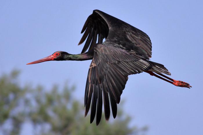
red deer, brown bear, wolf, sable, weasel, such rare species birds like golden eagle, black stork, whooper swan, demoiselle crane.
Sokhondinsky State Natural Biosphere Reserve
Kyrinsky, Krasnochikoysky and Uletovsky districts, area - 210,988 hectares.
This is the oldest nature reserve in the Trans-Baikal Territory, founded in 1973. It occupies the highest part of the Khentei-Chikoy highland with the Sokhondo mountain range, which, in turn, has two peaks - Big Sokhondo with a height of 2505 m above sea level and Small Sokhondo with a height of 2404 m. There are many rivers and lakes on the territory of the reserve. Lake Bukukun, located at an altitude of 1892 m above sea level, is especially picturesque.
The uniqueness of the Sokhondinsky Nature Reserve lies primarily in the diversity of its landscapes: steppe, taiga, mountain tundra, meadows, swamps, lakes, etc. are represented here. Accordingly, the plant and animal world reserve.
Different types of forests replace each other according to the height. The lower light-coniferous forest belt (1500−1600 m) is represented by Daurian and Siberian larch on the northern slopes and pine on the southern, relatively warm and well-lit slopes.
The upper dark coniferous forest belt (1600−1900 m) is primarily cedar forests different types. At the same time, mosses grow on 80% of the soil here. These forests have great importance— they are home to valuable fur-bearing animals.
The sub-alpine belt (1900−2100 m) is represented by sparse cedar and larch woodlands, turning into pine pine thickets. Higher up, the larch-elfin woodland gives way to mountain tundra.
The main inhabitant of the Sokhonda forests is the sable: in the protected area, the population density of this animal is 3-5 times higher than in neighboring areas where hunting is allowed. Siberian weasel, ermine, weasel, wolf, bear, and lynx are also common. Ungulates include wapiti, elk, musk deer, Siberian roe deer, and wild boar. Sometimes the river otter, listed in the Red Book of the Russian Federation, is found. In total, the reserve is home to 67 species of mammals and about 250 species of birds.
Next to the Sokhondinsky Nature Reserve, it is planned to create another Transbaikal national park, Chikoy. In addition, the Russian reserves “Burkalsky”, “Atsinsky”, “Mountain Steppe” and the Mongolian National parks"Onon-Bulj" and "Khan Khentiy". A project is currently being discussed to unite these territories into a large trans-border international reserve with the possible name “Sources of the Amur”.
State Natural Biosphere Reserve "Daursky"
Distribution of forests growing in specially protected areas
natural areas, according to functional significance
Ononsky and Borzinsky districts, area - 45,790 hectares.
The Daursky Nature Reserve was created in 1987 in the south of Transbaikalia. This is one of the few nature reserves in Russia steppe zone- it belongs to the Prionon-Torey district of the dry Mongol-Manchu steppes. In 1994, the Torey Lakes, which occupy most of the reserve, received the status of wetlands of international importance.
These lakes - Barun-Torey and Zun-Torey - are the largest in Transbaikalia. Once every 30 years, the lakes dry up and fill up again. At least 135 species of birds nest along the banks, many of which are protected. Six species of cranes can be found here: Japanese, black, gray, white, white-naped and demoiselle - more than anywhere else in the world. And for the relict gull, these lakes are the only nesting place in Russia and one of four known in the world. The Daursky Nature Reserve is included in the List of Key Ornithological Areas of International Importance, the International East Asian Network of Important Crane Reserves and the International Network of Important Anseriform Bird Reserves.
“Daursky” is the only habitat of the gazelle antelope in Russia. This ungulate almost completely disappeared by the 1970s, but thanks to the existence of the reserve it was preserved. The territory is also home to 17 species of rodents, including the Mongolian marmot (tarbagan). Among the predators live the fox, the steppe polecat, the wolf, the raccoon dog, the corsac dog, and manula cats have settled among the rocks.
The reserve is subordinate to the territory of the federal reserve “Tsasucheisky Bor” - a ribbon pine forest on the right bank of the Onon River. The origin of this island forest, surrounded on all sides by steppes, still remains a mystery. The boron is formed by a unique species of pine: some scientists define it as Krylov pine, others - as grave pine. At the same time, the grass canopy of the forest is represented by a steppe complex of species. Unfortunately, the fires of 1998–2003 caused serious damage to the Tsasucheisky Forest.
The Daursky Nature Reserve, together with the Tsasucheysky Bor Nature Reserve, the Chinese Lake Dalainor Nature Reserve and the Mongolian Mongol-Daguur Nature Reserve make up the Dauria International Protected Natural Area with a total area of 1.725 million hectares.
Prepared by Evgeniya CHABAK
The Trans-Baikal Territory is located mainly in the Amur basin: the drainage basin formed by the components (Shilka and Argun) and tributaries of the Amur occupies 56% of the region's area. This territory includes, in particular, the central and southern regions of the region, where about 90% of the population lives. Moreover, the basin has a transboundary nature, since it connects the Trans-Baikal Territory with neighboring provinces of China and Mongolia. The most typical for this territory are: ecological problems, such as a decrease in forest areas due to fires and deforestation, the influence of the mining industry and, first of all, gold mining, household pollution of watercourses and coasts, anthropogenic pressure on ichthyocenoses, and so on.
IN last years threats to aquatic and coastal ecosystems in the region have intensified or emerged. The catastrophic fires of recent years could not but affect the water-regulating function of forests. Projects for the construction of dams in riverbeds periodically arise or are revived large rivers(Shilka, Nercha, Amazar). Industrial growth in China has led to increased pollution of the Argun and increased water consumption for the needs of mining and agriculture in Inner Mongolia.
At the same time, in the Trans-Baikal Territory, the risks associated with cross-border Chinese investments in the timber industry and, in the future, in Agriculture. In particular, in the eastern border regions of the Trans-Baikal Territory (Mogochinsky, Tungiro-Olyokminsky, Sretensky, Gazimuro-Zavodsky, Nerchinsko-Zavodsky) clear cuttings of forests are planned in vast areas transferred to long-term lease, which may be one of the negative factors, which have a destructive impact on the state of both terrestrial and aquatic ecosystems over large areas. These threats require both assessment possible consequences, as well as taking the necessary preventive measures, including the creation of new specially protected natural areas (SPNA).
Currently, the areas of protected areas within the Trans-Baikal Territory account for 5.3% of the region’s territory. Some of them are two reserves (Sokhondinsky and Daursky), a national park (Alkhanay), natural Park(Arey) and 13 reserves are located entirely or partially in the Amur basin. However, predominantly small watercourses fell within the boundaries of these protected areas. Until recently, the region was practically deprived of protected areas in the river beds that belong to the category of large rivers (length more than 500 km) and determine the specifics of the regional part of the Amur basin - Shilka, Argun, Onon, Ingoda, Nerch, Gazimur and the Amur itself. Only a small part of them were associated with specially protected natural areas. Thus, the sources of the Ingoda are protected within the Sokhondinsky nature reserve, and a small (about 10 km) part of the Aginskaya Steppe regional nature reserve goes to the left bank of the Onon.
At the same time, in recent years, in the Chinese border territories along the right bank of the Argunia Amur, large reserves of Erguna, Vuma and Beidzikun have been created. To date, almost the entire Chinese coastal region in the lower reaches of the Argun, for about 300 km along the border with Russia, is occupied by specially protected natural areas, actively used, in particular, for the development of rural and ecological tourism.
It should also be noted that there are significant differences in the dynamics of forest areas on different banks of the Argun and Amur in recent years, manifested in a noticeable fragmentation of forest areas on the Russian side. Key reasons This should be sought, first of all, in transboundary differences in the organization of fighting forest fires.
This kind of imbalance in approaches to environmental management and conservation in the short term can lead to the formation of an extremely dangerous situation in geopolitical terms, in which the well-being and sustainability of the Chinese border regions will be ensured at the expense of both environmentally friendly forms economic activity, and the export of raw materials from Transbaikalia. This imbalance can cause not only long-term environmental, but also serious reputational consequences, both for the Trans-Baikal Territory and for the country as a whole; Solving this problem is impossible without finding comprehensive solutions, but it must undoubtedly include the creation of new protected areas as a reservoir for conservation biodiversity and potential for the development of ecotourism activities, including (and perhaps primarily) with the attraction of Chinese investments and tour operators. In each of these cases, those areas that are geographically linked to major watercourses may be of particular importance.
In this regard, in recent years, in the Trans-Baikal Territory, activity has intensified to create new protected areas, one of the functions of which would be to preserve not only basins, but also the main channels of large watercourses. As a result, justifications for the creation of a number of regional reserves were prepared, primarily such as “Relic Oaks”, Verkhneamursky and Sredneargunsky (Fig. 1).

Rice. 1. Borders of created and being created protected areas in the Russian-Chinese border area. 1- reserve “Relitovye oaks” (Russia); 2- Eerguna nature reserve (PRC); 3- reserve “Virgin Forest of Wuma” (PRC); 4 - Beijikun Nature Reserve (PRC); 5- reserve “Urushinsky” (Russia); 6 - reserve "Ulegir" (Russia).
Currently, only for one of the above-mentioned reserves - “Relic Oaks” - with the support of the Amur branch of WWF Russia, a full cycle of organizational measures has been carried out. This made it possible in 2011 to create a regional reserve with an area of 30,399.8 hectares in the Gazimuro-Zavodsky district of the Trans-Baikal Territory, which along its entire length (more than 80 km) overlooks the left bank of the Argun, adjacent to the Chinese Vuma reserve.
In 2013, an environmental and economic feasibility study was prepared for the creation of the Verkhneamursky regional reserve with a total area of 239,639 hectares, located in the Mogochinsky district. The reserve was organized to protect a valuable natural area, which includes the valleys of the Argun, Shilka and Amazar rivers in their lower reaches, the Amur valley in the upper reaches, as well as the basins of their mountain tributaries. The Shilka, Argun and the Amur formed at their confluence are a kind of “framework” of the river network. The entire left bank of the Amur from the confluence to the border with the Amur region, 46 km long, is located within the designed reserve. It should be noted that this reserve is adjacent to the Chinese reserves Vuma and Beijikun. Currently, documents for the creation of the reserve are at the approval stage.
In 2014, the region prepared an environmental and economic feasibility study for the creation of the Sredneargunsky regional reserve with a total area of 247,157 hectares, located in the Nerchinsko-Zavodsky district. The territory of the reserve is extended in the meridional direction mainly along the middle (for the Russian part of the basin) flow of the river. Argun. The reserve was organized to protect the left bank and adjacent ecosystems in the river basin, including its tributaries, including part of the basin major influx like R. Level The Sredneargunsky nature reserve is adjacent to the Chinese nature reserves of Eergun and Vuma. Currently, documents for the creation of this reserve are at the approval stage.
Thus, in the upper reaches of the Amur and in the estuary part of its main components Shilka and Argun, a whole cluster of Russian and Chinese protected areas is being formed. On the Chinese side, these are the Beidzikun, Eerguna and Vuma reserves, on the Russian side, the existing reserves “Relic Oaks” (in the Trans-Baikal Territory) and Urushinsky (in the Amur Region), as well as the created reserves Verkhneamursky and Sredneargunsky. After completing the process of their creation, it will be possible to talk about a cluster of seven protected areas with a total area of about 1.5-2.0 million hectares.
This potentially creates prospects for the organization international cooperation for the purpose of nature conservation and development of ecological and scientific tourism. The result of such cooperation may be the creation of a Russian-Chinese transboundary reserve with possible (in the future) excursion visits by tourists to adjacent territories, the organization of joint programs and a joint search for sources of financing for environmental activities on the basis of both national and international funds. It should be noted that the work to create new protected areas on key watercourses of the Amur Basin in the Trans-Baikal Territory will continue. First of all, this concerns Nercha - the last of big rivers basin, which does not have its own protected areas. Currently, several options for regional reserves are being considered - in the lower reaches (Nerchinsk Steppe), middle reaches (Nerchinsky) and upper reaches (Nerchugansky). In addition, a justification for the Duldurginsky reserve is currently being prepared, which will include coastal ecosystems and part of the river bed. Onon.
Transbaikal State University
Transbaikal State National Park is a true pearl of Buryatia. Unique landscapes of the eastern coast of Lake Baikal, valuable natural complexes, the safety of which was under threat, prompted the Government of the RSFSR in 1986 to issue a decree on the creation of a park in this area, under state protection.
This is a real paradise for animals: more than 44 species of mammals, 50 vertebrates, 241 species of birds, 3 species of reptiles and the same number of amphibians. Many representatives of the fauna are included in the Red Book of Russia.
The national park is part of a huge complex, a real repository of northern attractions and natural beauties called the Reserved Podlemorye. It includes two more parks - the Frolikhinsky reserve and All three environmental zones are part of the Lake Baikal site, which is under the protection of UNESCO.
Park features
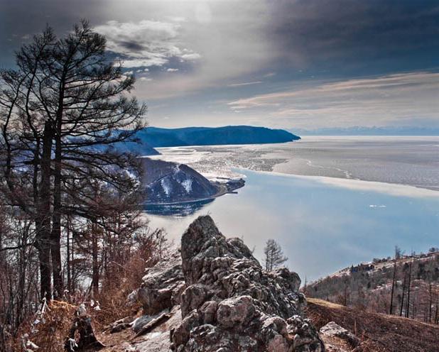
The territory of the protected area covers the Academichesky, Sredinny, Svyatonossky and Barguzinsky ridges and occupies a total of 269 thousand hectares. 37 thousand hectares is the water area of Lake Baikal, the deepest freshwater lake in the world.
Most of the reserve complex is occupied by mountain slopes, abundantly covered with thickets of birch trees, dwarf cedar, larch, pine and cedar taiga.

One of the most beautiful places The Svyatoy Nos Peninsula is considered: the Chivirkuy Isthmus connects it with the eastern coast of Lake Baikal. The top of the Academichesky Ridge, which is the underwater boundary between the northern and southern depressions of the Baikal Basin, is represented by the Small Ushkany Islands and the Bolshoi Ushkany Island.
This formation was called the archipelago
Chivyrkuisky Bay
Trans-Baikal National Park is famous for the largest freshwater seal rookery on Lake Baikal - the nerpa. This is an endemic of Lake Baikal and the only representative of the pinniped order. The largest number of seals is found on the Ushkany Islands, where their numbers sometimes reach 2,500 - 3,000 individuals. In autumn, during storms, seals (most often pregnant females) move to Chivyrkuisky Bay. However, this is not their wintering place: after healing and resting, the seals again go to open water, as the bay is covered with ice.
The bay is famous for its thermal springs, the most famous of which is Zmeevy. It owes its name to the population of the common grass snake that lives in the Arangatui swamps. The water temperature in the source sometimes reaches +50-60 degrees. The Nechaevsky and Kuliniye Bolots mineral springs are also popular among park guests.
The shores of the Chivyrkuisky Bay are strongly indented, the waters cut into the land for 25 kilometers. This feature has led to the appearance of small sandy bays up to five meters deep, protected from the winds, along the entire reservoir. One of the most notable is Ongokon Bay.

Five tourist routes give guests the opportunity to get acquainted with the inhabitants of the protected area, its beauty and breathtaking landscapes. From the very high point park - Mount Markovo, located on the Svyatoy Nos peninsula, offers an amazing panorama of the area.
Islands and park
The nature of Buryatia is diverse and beautiful in any of its manifestations. So, while taking a boat trip along the Chivyrkuisky Bay, you can admire real islands, the steep shores of which have turned into a refuge for numerous blue-gray ones that build their nests here.
Climatic features of the park
The park is located in the Central Baikal eastern climatic region, which is characterized by continental climate with warm, sometimes dry summers and long cold winter. The influence of Baikal softens weather in the coastal part of the protected area. average temperature in winter it is -19 degrees Celsius, in summer +14 degrees. The water temperature in the lake does not rise above +14 degrees even on the hottest days.
Water resources of the reserve
Transbaikalsky National Park is rich in water resources. Many small rivers flow here, among which the Bolshoi Chivyrkui, Malaya and Bolshaya Cheremshana stand out. The basins of these rivers are closed, so they carry their waters to Baikal. There are also lakes here: the largest of them are Arangatui and Small Arangatui, located on the Chivyrkuisky Isthmus and connected to the bay. Bormashova Lake is smaller in size and is famous for its mineral waters.

A special feature of the park is the presence of karst lakes - there are more than twenty of them.
Flora of Transbaikal National Park
The Trans-Baikal Territory is located in the taiga forest zone, which directly affects the structure of the vegetation cover of this area. It is due to the vertical zonation of the Transbaikal mountain regions. Forests mainly consist of coniferous trees: Gmelin larch, Siberian fir, pine, cedar and dwarf cedar.
A small area is occupied by deciduous forests, mostly represented by stone and broadleaf birches and aspens.
Transbaikal National Park is distinguished by an unusual distribution of mountain taiga forests compared to their location in the continental Siberian mountains. Thus, in the park the number of cedar-larch and larch trees is relatively small - their area occupies about 14 thousand hectares, and they are located on madders along river terraces, while in other Siberian forests such trees are represented in the majority.
Endemics and relics
The flora of the protected area is diverse, many plant species are endemic and relict. The most valuable of them settled in the highlands of the Ushkany Islands and the Holy Nose.

These include Chosenia, dwarf pine and dwarf birch communities, and Teeling's Borodinia.
Diversity of fauna
A real home for sables, wolves, wolverines, bears, foxes, squirrels, moose, brown bears, red-gray voles, hazel grouse, nutcrackers, musk deer, black-capped marmot and many other fauna representatives became the Transbaikal National Park. Animals feel completely safe here.
Among the representatives of amphibians there are rare species - Siberian and sharp-faced frogs. The six species of reptiles also found here include the common grass snake, the copperhead snake and the viviparous lizard.
Among the birds, both resident and vagrant, you can find white and yellow wagtails, brown-headed chickadees, coal tits, dubrovniks, nuthatches, nutcrackers, lapwings, snipe, black gulls, common terns, glaucous and herring gulls. Sometimes in the park you can see a black stork (the nesting site of which remains a mystery), a golden eagle, a white-tailed eagle, a peregrine falcon and an osprey.
Another rare bird that has disappeared from the coast of Lake Baikal and lives in small numbers in Chivyrkuisky Bay is the great cormorant.
Many bird species make their nests in swamps, hidden from human eyes and mostly located on the Chivyrkuisky Isthmus. Here is also the least transformed ecosystem in the world - the Arangatui swamps, where moose, wood grouse, and muskrats live.
The most numerous group of waterfowl is represented by the mallard, goldeneye, pintail, whooper swan, teal and
There are also owl-like birds in the park: short-eared and long-eared owls, eagle owls and snowy owls - very rare guests, found only in winter or in places where humans rarely set foot.
The national parks of Buryatia, including the Transbaikal National Park, are rich in diverse representatives underwater world. Thus, in the reservoirs there are perch, ide, Siberian grayling, dace, burbot, sturgeon, pike, roach and an endemic species - the small golomyanka.
Transbaikalsky National Park: how to get there
The closest settlement to the park is the village of Ust-Barguzin.
You can get here by land or water. The optimal route by land is the services of private transport, which departs from Irkutsk along the coast of Lake Baikal. From the capital of the Republic of Buryatia - the city of Ulan-Ude - you can get to the park by minibus or regular bus.
The distance to the reserve is about 275 km and the journey takes approximately 5-6 hours.
Please note that most of the route is on a gravel road. For people who prefer the water route, private flights depart from the port of Baikal, as well as from the villages of Khuzhir, Nizhneangarsk and Listvyanka.
Having visited this park, you will not regret it for a minute, because it is not only the hallmark of Baikal, but also a real oasis of natural wonders that the Trans-Baikal Territory is so rich in!