There are about 80 seas on our planet, and each of them is unique in its own way. Some are part of the World Ocean, some attract tourists with picturesque views or the diversity of their flora and fauna. But all seas have common feature- they are salty. The alkali content in each of them is different, and today we will talk about what they are - the saltiest seas in the world.
10
In the last position in the ranking of the saltiest seas in the world is the White Sea with an area of only 90 thousand square meters. It is located in the north of the European part Russian Federation and refers to the Arctic Ocean. The sea is cold, you can’t really swim in it, because in summer the water warms up to no more than 15 degrees Celsius, while in winter its temperature is -1 degree. The White Sea is fed by the waters of such large rivers as the Northern Dvina, Onega, Kem, Ponoi, as well as many small reservoirs, and the depth of its bottom ranges from 50-340 meters.
9 Chukchi Sea
It is located between Alaska and Chukotka, characterized by a high concentration of salts - at the level of 33%. The cold waters of this reservoir, even in warm time years do not warm up to more than +12 degrees. Despite low temperature water (in winter -1.8 degrees), the fauna of the Chukchi Sea amazes with its diversity. In addition to many species of fish, walruses and seals live here, polar bears live on ice floes, and in the summer there are lively bird colonies. Depth differences range from 50 to 1256 meters.
8

The area of the reservoir, located between the islands of Severnaya Zemlya and Novosibirsk, is 662 thousand square km. The water temperature here is one of the lowest on the planet - it never rises above 0 degrees. Most of the year the waters are covered with ice, and several species of fish live at the bottom.
There are a couple of dozen islands in the sea where remains of mammoths are found even today.
7

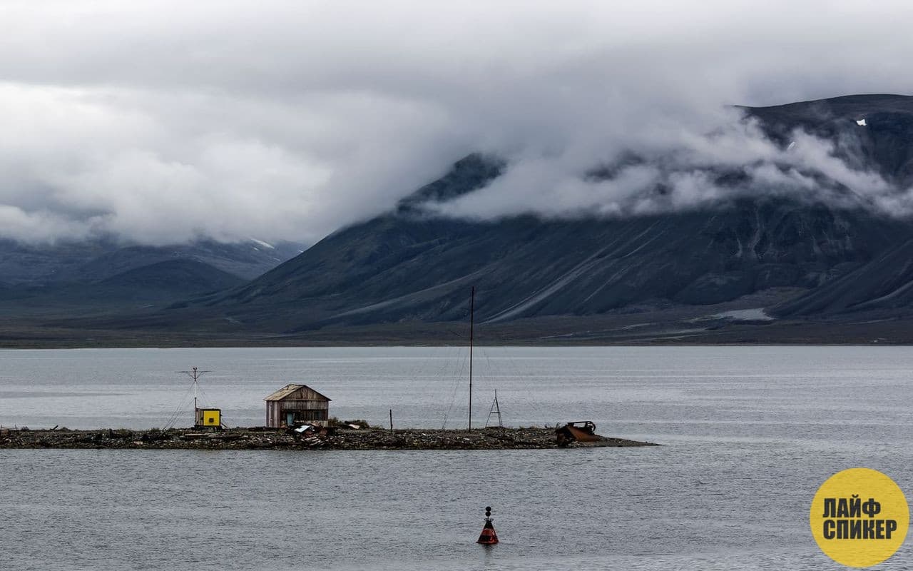
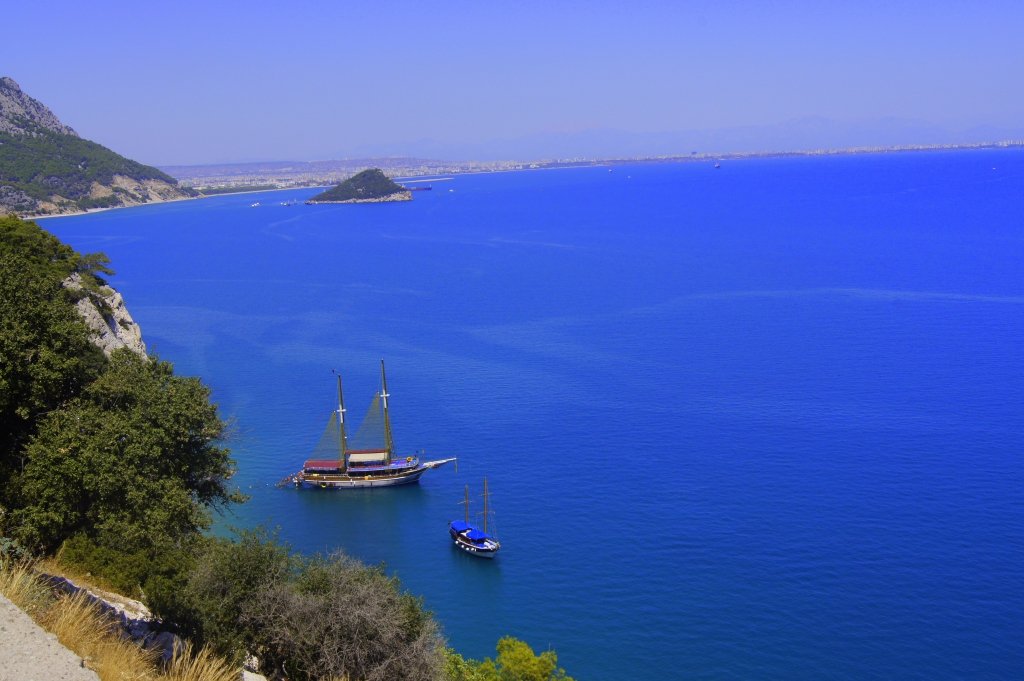
A salty sea on the edge of the Arctic Ocean, it washes the shores of two countries at once - Russia and Norway. The area of the reservoir is 1,424 thousand square kilometers, the maximum depth is 600 meters.
The sea plays a key role in fishing and transport communications; it is home to two large ports - the Russian Murmansk and the Norwegian Vardø.
There are often storms here, and undersea world rich different types fish and plankton. Mammals are also found here - seal, seal, polar bear, beluga whale.
6

Square Sea of Japan– 1062 thousand square kilometers, and the maximum depth is 3741 meters. The highest recorded salt content is 35 percent. The Sea of Japan is one of the most salty seas on the planet and the saltiest in Russia. The northern part of the reservoir freezes in the cold season, the climate here is moderate, in the summer the air above the sea warms up to 25 degrees Celsius. Animal world rich and varied. There are many species of fish and mammals here, and fishing for crabs, scallops, and algae is carried out.
The most salt Lake in Russia - Baskunchak. The salt content in it reaches 37%
5

Thanks to the high salt content in the Ionian Sea, it is easy to learn to swim - the water literally keeps the swimmer on the surface. The area of the reservoir is 169 thousand square kilometers, and the greatest depth is 5121 meters. The bottom off the coast is covered with sand or shell rock; the climate here is very favorable, which contributes to the development of tourism. The waters of the Ionian Sea warm up to 25.5 degrees in summer, minimum temperature water in winter - 14 degrees Celsius.
4

Salts in the waters Aegean Sea so much so that doctors advise after swimming here to wash under running fresh water in order to avoid skin irritation. The water temperature ranges from 14 (in winter) to 24 degrees (in summer). This is one of the most ancient bodies of water on the planet; the age of the Aegean Sea is more than 20 thousand years. IN Lately ecological situation here it leaves much to be desired, the underwater world is becoming impoverished due to the death of plankton, which is necessary for feeding fish, although previously fish and octopuses were caught in these places on an industrial scale.
3

This sea stretches between Europe and Africa; in addition to the fact that it is one of the saltiest bodies of water on the planet, it is also rightfully considered the warmest. In summer the waters warm up to 25 degrees, and in winter the temperature is sea depths does not fall below 12 degrees. The flora and fauna here are more than diverse; some species of fish living in the Mediterranean Sea are listed in the Red Book. Its area is 2,500 thousand square kilometers, and its maximum depth is 5,121 meters.
2

Despite the high alkali content, sharks, dolphins and stingrays live in the waters of the Red Sea. The unique feature of the sea is that average temperature water changes little throughout the year, its maximum value is 25 degrees.
The area of the reservoir is 450 thousand square kilometers, most of it is located in tropical zone with appropriate climatic conditions.
1

Our planet is the owner of about 80 seas, which together make up a certain part of the World Ocean. All sea water is, to a greater or lesser extent, salty. Our top 10 saltiest seas in the world will tell you about those bodies of water whose waters have the maximum saturation with salts.
10 White Sea
Located in the north of the European part of Russia. Being an inland sea, it belongs to the Arctic Ocean. Its water surface area is only 90,000 square meters. km., which makes it the second (after Azov) smallest sea. The White Sea is fed with its waters by the rivers flowing into it (Mezen, Onega, Kem, Northern Dvina, etc.). This influx of river water has resulted in the salinity of the surface water layer being only 26 ppm, but the salinity of the untouched deep waters is 31 ppm.
9 Chukchi Sea

Located between Chukotka and Alaska at the very edge of the Arctic Ocean. The area of its water reaches 589,600 square meters. km. In winter, the salinity of the under-ice layer of water increases to 33 ppm. In summer, salinity levels reach 28 ppm. These people live here major representatives fauna - polar bears, walruses, seals, whales, and fish - navaga, grayling, char, cod, etc.
8 Laptev Sea

Located on the edge of the Arctic Ocean. The area of the surface layer of water is 762,000 square meters. km. Several large rivers flow into it - Lena, Anabar, Khatanga, Olenek, Yana, the waters of which affect the salinity of the sea. Also, salinity depends on the melting of ice, the season, and the depth. So, in winter, salinity in the southern part reaches 20-25 ppm, and in the northwestern part it reaches 34 ppm. In summer, salinity decreases to 5-10 ppm and 32 ppm, respectively.
7 Sea of Japan

Is a marginal sea consisting of Pacific Ocean, separated from it by the Japanese islands. The surface water area is 1,062,000 square meters. km. In winter, ice covers only the northern part of the sea. The salinity of surface waters in the sea varies between 33.7 and 34.3 ppm.
6 Barents Sea

Located on the edge of the Arctic Ocean. The waters of this sea wash the shores of Norway and Russia. Water surface area – 1,424,000 sq. km. The sea is fed by the waters of two large rivers - Pechora and Indiga. Salinity in surface water layers has different meanings depending on location: in the north - 33 ppm, in the east - 34 ppm, in the southwest - 35 ppm. In spring and summer, these indicators slightly decrease, but in winter they increase. The Barents Sea has a rich flora and fauna.
5 Ionian Sea

Is a part Mediterranean Sea. The Ionian Sea washes the shores of Southern Italy and Greece. Its water surface area is 169,000 square meters. km. The bottom of the sea is a basin covered with sediments, the maximum depth of which reaches 5121 m. These figures are the greatest depth of the Mediterranean Sea. Salinity in the surface waters of the sea exceeds 38 ppm.
4 Aegean Sea

It is a semi-enclosed sea with islands, the number of which reaches two thousand. It is part of the Mediterranean Sea and is located between the island of Crete, the Balkan Peninsula and Asia Minor. Water surface area 179,000 sq. km. The salinity of the surface water layer varies between 37 and 40 ppm. Water temperatures and salinity are constantly increasing, which is caused by global warming.
3 Mediterranean Sea

This is an intercontinental sea, the area of the surface water layer of which is 2,500,000 square meters. km. After all, its components are 11 seas. The waters of such large rivers as the Tiber, Po, Ebro, Nile and Rhone flow into the Mediterranean Sea. The salinity of the surface layer of water varies between 36 and 39.5 ppm. High evaporation contributes to such indicators.
2 Red Sea

Is an inland sea Indian Ocean. Located between Africa and the Arabian Peninsula. Its water surface area is 438,000 square meters. km. Most of the Red Sea lies in the tropical zone and washes Egypt, Sudan, Saudi Arabia, Israel, Jordan, Yemen, Djibouti, Eritrea. The impeccable transparency of the water in the Red Sea is explained by the absence of rivers flowing into it, which usually bring silt and sand into the sea waters. The salinity of the water reaches 42 ppm.
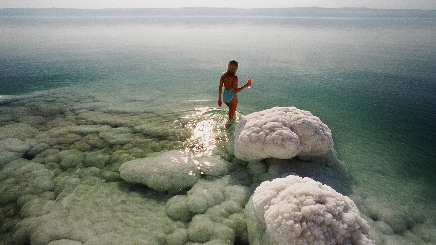
1 Dead Sea

The sea is located between Israel, Jordan and the Palestinian Authority. The water surface area is almost 810 square meters. km. The water level in the reservoir drops by about 1 m every year. And as a result, the Dead Sea is one of the saltiest bodies of water on Earth. The salinity of its waters is 300-310 ppm.
Each of these seas is unique in its own way. Therefore, if you have the opportunity and desire, it is worth seeing each of them.
) or PSU (Practical Salinity Units) units of the Practical Salinity Scale.
| Element | Content, mg/l |
|---|---|
| Chlorine | 19 500 |
| Sodium | 10 833 |
| Magnesium | 1 311 |
| Sulfur | 910 |
| Calcium | 412 |
| Potassium | 390 |
| Bromine | 65 |
| Carbon | 20 |
| Strontium | 13 |
| Bor | 4,5 |
| Fluorine | 1,0 |
| Silicon | 0,5 |
| Rubidium | 0,2 |
| Nitrogen | 0,1 |
Salinity in ppm is the amount of solids in grams dissolved in 1 kg sea water, provided that all halogens are replaced by an equivalent amount of chlorine, all carbonates are converted to oxides, and organic matter is burned.
In 1978, the practical salinity scale (PSS-78) was introduced and approved by all international oceanographic organizations, in which the measurement of salinity is based on electrical conductivity (conductometry), and not on water evaporation. Oceanographic CTD sounders became widely used in marine research in the 1970s, and since then salinity has been measured primarily electrically. To check the operation of electrical conductivity cells that are immersed in water, laboratory salt meters are used. In turn, standard seawater is used to check salinity meters. Standard sea water recommended international organization IAPSO for checking salinity meters, produced in the UK by the Ocean Scientific International Limited (OSIL) laboratory from natural sea water. If all measurement standards are met, a salinity measurement accuracy of up to 0.001 PSU can be obtained.
The PSS-78 scale produces numerical results similar to mass fraction measurements, and differences are noticeable either when measurements with precision better than 0.01 PSU are required or when the salt composition does not correspond to the standard composition of ocean water.
- Atlantic Ocean - 35.4 ‰ Highest salinity surface water in the open ocean is observed in subtropical zone(up to 37.25 ‰), and the maximum is in the Mediterranean Sea: 39 ‰. In the equatorial zone, where it is noted maximum amount precipitation, salinity decreases to 34 ‰. A sharp desalination of water occurs in the estuary areas (for example, at the mouth of La Plata - 18-19 ‰).
- Indian Ocean - 34.8 ‰. The maximum salinity of surface waters is observed in Persian Gulf and the Red Sea, where it reaches 40-41 ‰. High salinity(more than 36 ‰) is also observed in the southern tropical zone, especially in eastern regions, and in the northern hemisphere also in the Arabian Sea. In the neighboring Bay of Bengal, due to the desalinating influence of the Ganges runoff with the Brahmaputra and Irrawaddy, the salinity is reduced to 30-34 ‰. The seasonal difference in salinity is significant only in the Antarctic and equatorial zones. In winter, desalinated waters from the northeastern part of the ocean are transported by the monsoon current, forming a tongue of low salinity along 5° N. w. In summer this language disappears.
- Pacific Ocean - 34.5 ‰. They have maximum salinity tropical zones(maximum up to 35.5-35.6 ‰), where intense evaporation is combined with a relatively small amount of precipitation. To the east, under the influence of cold currents, salinity decreases. High precipitation also reduces salinity, especially at the equator and in the westerly circulation zones of temperate and subpolar latitudes.
- Arctic Ocean - 32 ‰. In the Arctic Ocean there are several layers of water masses. The surface layer has a low temperature (below 0 °C) and low salinity. The latter is explained by the desalination effect of river flow, melt water and very weak evaporation. Below there is a subsurface layer, colder (up to −1.8 °C) and more saline (up to 34.3 ‰), formed when surface waters mix with the underlying intermediate water layer. The intermediate water layer is Atlantic water coming from the Greenland Sea with a positive temperature and high salinity (more than 37 ‰), spreading to a depth of 750-800 m. The deep water layer lies deeper, forming in winter time also in the Greenland Sea, slowly creeping in a single stream from the strait between Greenland and Spitsbergen. The temperature of deep waters is about −0.9 °C, salinity is close to 35 ‰. .
The salinity of ocean waters varies depending on latitude, from the open part of the ocean to the shores. In the surface waters of the oceans, it is lower in the equator region, in polar latitudes.
| Name | Salinity, ‰ |
|---|---|
The topic of the second assignment on geography in the Unified State Exam format sounds like "Lithosphere. Atmosphere. Hydrosphere."
To complete this task, you need to know the salinity of most seas, the percentage composition of the atmosphere, be able to correlate temperature changes with an increase or rise in the earth's surface above sea level, understand the dependence of atmospheric pressure on the height of the earth's surface, and distinguish between relative and absolute humidity.
Required theory:
To begin with, it is worth clarifying that the task is divided into many subtypes, which becomes clear from its name. Therefore, the theory and procedure for performing the work vary significantly.
1 task type: Atmosphere pressure.
The lower the earth's surface is to sea level, the higher the atmospheric pressure.
2nd task type: salinity of the seas.
Tropical seas are saltier than northern ones.
In general, it is better to memorize a ready-made table of salinity of the seas than to try to remember which of them can be classified as tropical and which not. Personally, I remembered one of the mnemotic rules when writing a story, somehow using the names of the seas in it. You can come up with your own more effective way.
The table below does not list all the seas, but I didn’t see any seas other than them on the samples.
TABLE OF SALINITY OF THE SEA:
Red sea
Mediterranean Sea
Barents/Caribbean/North Seas
Japanese Sea
Sea of Okhotsk
Bering Sea
Black Sea
Baltic Sea
Caspian Sea
41.5 ppm
39.5 ppm
35 ppm
34 ppm
32 ppm
up to 32 ppm
up to 18 ppm
15 ppm
13 ppm
3 type of task: percentage of gases in the atmosphere.
Naturally, there are quite a lot of gases in the atmosphere, and the percentage of some of them is very small. It’s worth remembering the ones highlighted in bold; I personally never came across the rest in test assignments.
PERCENTAGE CONTENT OF GASES IN THE ATMOSPHERE:
Nitrogen
Oxygen
Carbon dioxide
Hydrogen
4th task type: dependence of air temperature on the rise of the earth's surface above sea level.
The higher the earth's surface is above sea level, the lower the air temperature.
5 task type: relative and absolute humidity air.
Absolute humidity - water vapor content in 1 m^3 air [g]
Relative humidity [%]
This task can also be divided into subtypes, so everything should be shown clearly.


1. If the relative humidity in the table is the same, but it is necessary to determine the temperature, then:
The higher the absolute humidity (g), the higher the temperature.
2. If the air temperature in the table is the same, but it is necessary to determine relative humidity air, then:
The more water vapor, the higher the relative humidity.
3. If the absolute humidity in the table is the same, but it is necessary to determine the air temperature, then:
The higher the relative humidity, the lower the air temperature.
Examples of the five Task Types:

1. atmospheric pressure.
At the points indicated by numbers in the figure, atmospheric pressure measurements are simultaneously taken. Arrange these points in order of increasing atmospheric pressure (lowest to highest).
The task can also be presented in the form of a table or graph, but the principle of its implementation does not change.
2. salinity of the seas.
Arrange the seas in order of decreasing salinity of surface waters (from highest to lowest).
1) Barentsvo;
2) Black;
3) Mediterranean.
3. percentage of gases in the atmosphere.
Arrange the gases in order of increasing their content in the atmospheric air (from lowest to highest).
1) Oxygen;
2) Nitrogen;
3) Hydrogen.

4. dependence of air temperature on the rise of the earth's surface above sea level.
At the points indicated by numbers in the figure, air temperature measurements are simultaneously taken. Arrange these points in order of decreasing air temperature (from highest to lowest).
The task can also be presented in the form of a table or other graph, but the principle of its implementation does not change.

5.2. relative and absolute air humidity.
(The air temperature is the same, but the absolute humidity is not).
At the points indicated in the table by numbers, measurements of the water vapor content in 1 m^3 of air and temperature are simultaneously carried out. Arrange these items in order of increasing relative humidity (lowest to highest).

5.3. relative and absolute air humidity.
(absolute humidity is the same, but relative humidity is different).
At weather stations 1, 2 and 3, the water vapor content in 1 m^3 of air is simultaneously measured and the relative humidity of the air is determined. The obtained values are shown in the table. Arrange these weather stations in order of the increase in air temperature at them at the time of taking these measurements (from lowest to highest).
In any sea the water is very salty. But there are bodies of water where the amount of salt is so great that you can’t even swim there. The saltiest sea in the world is not called the Dead Sea for nothing. Let's tell you more about it and other bodies of water with this feature.
A unique landmark of our planet is actually a lake. The water evaporates from it very quickly due to high temperature air. A huge amount of salt remains, which amounts to 30% of the volume here (for comparison: in the ocean - only 3.5%).
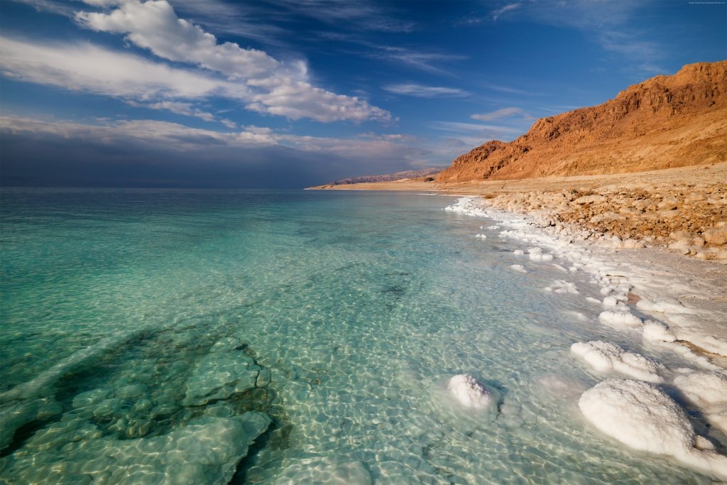
The coast of this reservoir is also interesting. There are many healing muds and thermal springs, attracting tourists. According to legend, King Herod himself loved to swim in them.

Along the shore there are mountains and pillars of salt. They were formed due to powerful underground tremors, pushing salt to the surface like a cork. The largest such mountain has a height of 250 meters and is called Sedom.
It is impossible not to mention the air over the Dead Sea. It is unique because it contains 15% more oxygen than the planetary average. This is due to the location of the reservoir below generally accepted sea level and high atmospheric pressure in this area.

It is one of the youngest on our planet, but unusual flora and fauna have already formed here. Since, as already mentioned, the Dead Sea is actually a lake, the Red Sea can be considered the most salty sea in the world (4.1% salt in water).

This amount of salt is due to the fact that not a single fresh river flows into the reservoir. If the Dead Sea is not suitable for life, then in the Red Sea, on the contrary, there is an unusually wide range of living creatures.
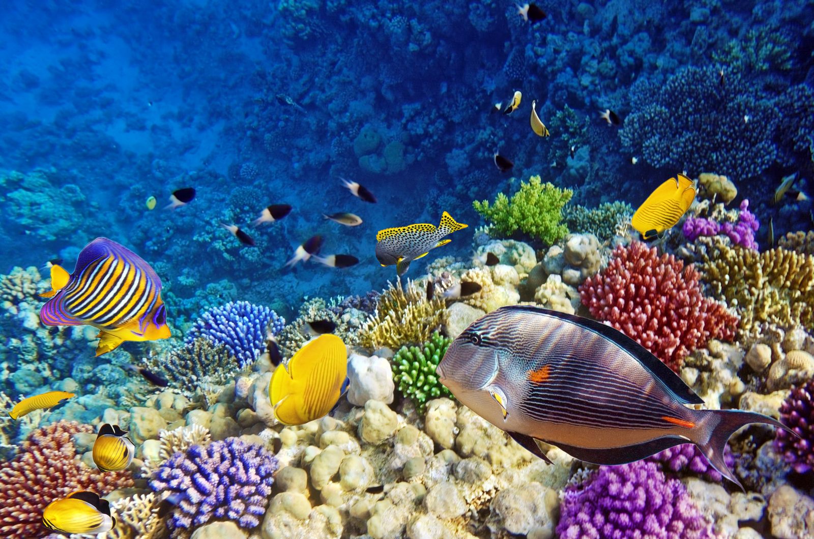
In addition, the water in it is very warm, and not only from the sun. Warm streams of water also rise from the bottom, so even in winter the temperature of the liquid here does not fall below 21 degrees Celsius.

The name, according to historians, comes from the fact that the ancient people living to the north of these places associated the color red with the south. The Red Sea was mentioned in documents as early as the 2nd century BC.

The uniqueness of this object is that its waters wash three parts of the world at once - Africa, Asia, and Europe. Hence the name. Man began to develop this territory 4 thousand years ago, and several great civilizations developed here at once.

The sea is almost entirely inland, connected to the Atlantic only by the narrow Strait of Gibraltar and several even smaller ones. The coastline of the reservoir is very winding and includes many islands and bays.
The Mediterranean has a very special climate, similar to subtropical. In winter it is warm and pleasant, in summer it is hot and dry. Hurricanes and storms also sometimes occur in winter.

The plants and animals here resemble those of the Atlantean and are clearly of the same origin. Waters with a salt content of 3.9% are rich in mackerel, flounder, tuna, squid, and other shellfish. There are also sharks.

The waters of this sea contain 3.8% salt. And it is known, first of all, for the huge number of islands of different sizes - there are more than 2000 of them. At one time, civilizations such as the Greek and Mycenaean flourished here.

This number of islands is associated with the process of sea formation. Previously, there was land here, then it filled with water, and the protruding areas turned into islands.

The banks of the reservoir are rocky and have a large number of deserts. The bottom of the sea mostly consists of sand, overgrown with small algae. The water is very warm; in winter its temperature does not drop below 11 degrees.

The Aegean Sea has long been famous for its rich wildlife. It has always given people a huge amount of fish and seafood. Unfortunately, this trend is now declining as the sea becomes dirtier.

This geographical feature also known to people since ancient times. Proof of this is its mention in Homer’s works “Odyssey” and “Iliad”. Today it is an attractive place for tourists due to its incredibly beautiful scenery.

The seabed consists of shell rock - a mixture of shell remains sea inhabitants, sand and silt. The coasts are completely covered with beaches, not only sandy, but also pebble and rocky. The water contains approximately 3.8% salt.

The fauna of the Ionian Sea is in many ways reminiscent of the Mediterranean. There are also a lot of mullet, tuna, and mackerel here. You can see prickly ones everywhere sea urchins, because of which it is not recommended to enter the water barefoot.

The name of the sea, according to one version, comes from the name of the cow Io, who in the legend swam across it. Another version says that a tribe of Ionians once lived on the banks of the reservoir. Finally, the third version is associated with the color of water at sunset - “ion” - purple.

The salinity of this reservoir reaches 3.5%. It is located between Russia, Japan and the two Koreas, while being almost completely isolated from the Pacific Ocean. Water exchange is carried out by only a few channels.

The sea has a fairly straight coastline and several small islands in the eastern part. Large islands are missing. There is a large bay named after Peter the Great, in which the cities of Nakhodka and Vladivostok are located.

The water in this sea is quite warm, monsoons often occur, and typhoons occur in the autumn. Peter the Great Bay and the Gulf of Tatar are covered in winter with a layer of ice that lasts for four months.

The water is very clear, visibility through it reaches 10 meters. It also contains a large number of dissolved oxygen, especially in the north and west. In these places the liquid is colder.


The sea is almost always covered with ice due to the mixing of three water masses - the cold waters of the Arctic, the North Atlantic Current and warm coastal waters. Only in September the reservoir is briefly freed from ice.

From the southwest, the sea shores are very rocky, densely indented by fjords. But to the east the coast becomes much lower and smoother. There are quite a few islands in the Barents Sea, of which the largest is Kalguev Island.

The reservoir is actively used for fishing and seafood, as well as for shipping. Some important trade routes pass through it. The most significant port is the city of Murmansk.

Laptev sea
The water in this sea is also 3.5% salty. It is located between the New Siberian Islands and Severnaya Zemlya. The ice cover lasts almost the entire year, and the climate is generally cold and arctic.

The sea is named after Russian travelers, brothers Dmitry and Khariton, named Laptev. They are the ones in XVIII century actively developed these places. But this name was approved only in 1935.

Flows into the Laptev Sea deep river Lena, forming a large delta. Other, smaller rivers also flow into the reservoir - Yana, Anabar, Olenek. There are many bays and bays along the coastline.

The seas of our planet are an inexhaustible source useful resources, but for ordinary person They are attractive not because of this, but because of their unique features. By visiting each of the listed reservoirs, you can see how different they are, but equally beautiful.